





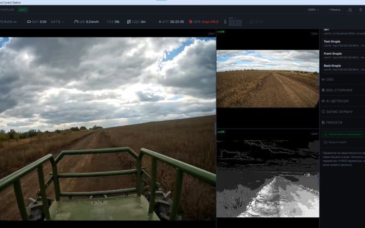
Ukrainian company TechUnity has unveiled AetherLink GS, a software control station for ground robotic systems. The current version, 1.2.0, includes two artificial intelligence-based features: road-keeping and a drone detector, including FPV drones. The company said this in a press release.
As the developers explained, the “Road-Keeping” feature analyses the camera image, identifies the road and automatically keeps the vehicle moving along it. It works day and night, can be configured for a specific platform, and is activated via a button in the camera window or a button on the controller.
The built-in drone detector analyses video locally on the operator’s computer, without sending the image to a cloud service. For drone detection, the company said there are models for cameras with 1.7 mm and 2.8 mm lenses that work in day and night modes, as well as a separate model for a thermal imaging camera.
According to TechUnity, the detector is already being used by combat units of Ukraine’s Defence Forces, and the “Road-Keeping” feature is also being used in combat conditions.
AetherLink GS supports simultaneous operation with multiple IP cameras and automatic camera discovery on the network. The operator can switch between day and night modes, and the image can be overlaid with the dimensions of the ground robotic system and the movement trajectory, which help with orientation while manoeuvring. The station also includes built-in screen recording and two-way audio communication via the microphone and speaker of a compatible camera.
Read alsoRobotisation of the Kill Zone: The History of Using Ground Robotic Systems and Today’s Challenges and Tasks
For communications with the ground robotic system, Starlink, LTE, Mesh or an automatic switching mode can be selected. Backup switching between available channels and load balancing are provided. The operator can see the active channel, connection status and data transmission latency, and can also check the status of the Starlink terminal directly in the programme.
The map displays the position of the ground robotic system. The programme supports route planning, movement along a specified track, and saving and sharing routes. Telemetry shows the vehicle’s operating mode, voltage, battery discharge graph and other parameters selected by the operator.
Reverse is engaged with a single button and preserves the familiar logic of the sticks when moving backwards. This makes it possible, for example, to drive using the image from the rear camera if the front one becomes unavailable, the developers explain.
The operator can change the layout of panels, and display video or the map on a second monitor for the navigator. Control, channel and map settings are saved as a configuration for a specific ground robotic system, which can be transferred to another laptop. AetherLink GS supports joysticks, gamepads and gaming steering wheels, with configuration of axes, buttons and control smoothness.
At present, AetherLink GS works in tandem with JARVIS, TechUnity’s onboard computer for ground robotic systems, which equips ground robotic platforms from more than 25 manufacturers. For ground robotic systems with JARVIS, the ground control station is included in the standard software package and is provided free of charge. TechUnity is also working out the procedure for providing AetherLink GS for use by the military and by manufacturers of ground robotic systems with other onboard computers.
As a reminder, the Ukrainian company Drone Fight Group developed the “Kaban” remote vehicle control system, which makes it possible to turn ordinary vehicles into unmanned ones.
According to the developers, “Kaban” can be installed on various car models without interfering with their design. The system supports both remote and manual control, between which it is possible to switch.