


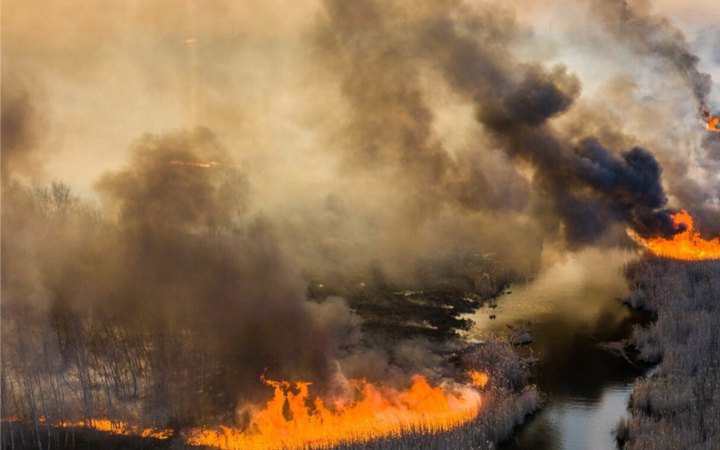
Satellite data indicate the occurrence of 31 large fires in the exclusion zone, with a total area of more than 10,111 hectares.
This was reported by the Ministry of Ecology and Natural Resources.
In addition to warfare, provoking the fires, occupiers are deliberately burning forests and fallows, increasing the level of radioactive air pollution, emphasized the agency.
"Prior to the full-scale russian invasion, the background radiation in the exclusion zone was controlled by the Automated Radiation Control System at 39 points. Now, such control and firefighting are impossible due to the occupation of the exclusion zone by russian troops," - the Ministry said.
Satellite images from NASA and the European Space Agency (ESA) are helping to capture the fires.
"However, due to the limitations of remote probing data, currently used by our specialists, we suppose the existence of a significant number of smaller outbreaks is possible," - the Ministry mentioned.
Currently, satellite data indicate the occurrence of 31 large fires. They have encircled natural ecosystems as well as abandoned villages of the exclusion zone.
"Due to favorable weather conditions, fires are currently self-extinguishing. However, due to a number of factors, the number and area of fires are expected to increase in the near future. It is possible that fires can reach catastrophic scopes of 2020 under favorable conditions.
As of March 26, the following fires were localized:
Denysovytske forestry - 4 centers, the approximate ignition area - 724.22 hectares;
Kotovske forestry - 11 centers, natural ecosystems were affected and the resettled villages Bober, Pukhove, Nova Markivka, Shevchenkove, Kotovske, Zhovtneve, Volodymyrivka, Tarasy and Poliske. Approximate fire area - 7672.35 hectares;
Korogodske forestry - 10 centers, natural ecosystems, and resettled villages Stechanka and Cherevach were affected. Approximate ignition area - 549.29 hectares;
Dityatkivske forestry - 4 centers, natural ecosystems, and resettled village Rozsokha were affected. Approximate fire area - 359.32 hectares;
Lubyanka Forestry - fire encircled natural ecosystems and areas of resettled villages Buda and Tovstyy Lis. Approximate ignition area - 771.87 hectares;
Parishivske forestry - fire area - 34.24 hectares.
On March 23, Ukraine informed the International Atomic Energy Agency that firefighters were fighting forest fires near the Chernobyl nuclear power plant. The IAEA has reported an increased concentration of cesium.
On March 24, the Ministry of Ecology and Natural Resources reported that most of the fires in the Chernobyl NPP zone were localized, and the level of cesium does not endanger health.